Among the houses
Luftwaffe records for 1942 are sparse and some details are the author's interpretation of what little information is known. Individual's details are not recorded in this account and what is known about each casualty and location can be viewed via the By name or By location lists.
The timings of the Purple, Red and White alarms for the different East Yorkshire "Warning Districts" are shown below.
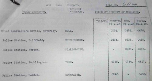
As a measure of the success of the German deception plan, the time between the preliminary caution (Purple) warning and the action warning (Red) was quite short.
The first Luftwaffe ordnance was falling at the same time as the "Red" warning was issued and the sirens sounded at 02:44hrs.
This was York's 89th air raid warning of the war. The first was October 17th 1939. Warnings were as short as 10 mins (15/8/40) and as long as 7hrs 37mins (2/3/41).....East Riding Archives File: CD/1.
As has been described previously, the Luftwaffe Pathfinders were not always first over the target and it is not known who dropped the first bombs or flares. From combat and eye witness reports, incendiary bombs, high explosive bombs and flares were all used at some point in the raid.
Early in the raid at 02:50hrs, possibly due to a lack of early Pathfinder support, some 400 incendiary bombs were reported at Dunnington (in open ground near Grimston Hall).
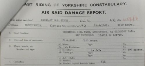
The damage report for the Dunnington incendiary bombs. Image courtesy of the East Riding Archives....POL3/6/7/25
Some German bombers attacked directly from the east whilst other circled to the north and attacked along a NE-SW line.
They flew at heights ranging from 4,000 to 12,000 feet and then dived down to (as low as) 1,000 feet to drop their payload over their targets.
The Luftwaffe definition of a major attack was one where at least 100 tons of bombs were dispatched.
The final survey concluded that 115 bombs weighing about 50 tons were dropped within the city boundary.
A further 40 bombs weighing about 22 tons fell outside the city boundary (on or around RAF Clifton).
An estimated 3-5 tons of incendiary bombs were also dropped.
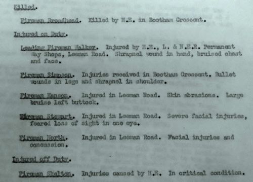
Many eye witnesses report that the German bombers machine-gunned the streets. Those most likely to be killed or wounded were Civil Defence personnel. A post-raid report indicates that one fireman (Fireman Simpson) received bullet wounds but the origin of the bullets is not known (German or RAF).
Document copyright of the National Archives.
Overall there were around 20 major incidents where one or more deaths were reported. The three worst incident areas (Botham, Amberley/Chatsworth & Spalding Avenue) accounted for over 65% of the total deaths.
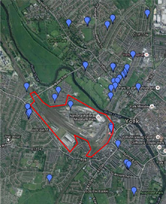
This map (a screenshot from York Stories with the 1941 German target area added) shows the locations of all but three of the non-military deaths. One clear line of destruction can be seen in the Botham area as well as other clusters where a significant number of deaths occurred. It is interesting to consider that many of the incidents outside the targeted railway area could be due to either 'creepback' or simply near misses. Some of the more northerly "misses" may have been targeted at the Clifton Moor airfield which used to be just to the north of this modern map.
Spalding Avenue in Clifton suffered greatly from bombs most likely intended for the airfield. The worst single incident occurred in this street at No:110 where eight were killed in a shared garden shelter. The build quality of the air-raid shelters in this street was the subject of detailed analysis following the raid.
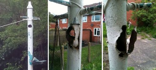
The washing line pole at 110 Spalding Avenue still bears the shrapnel scars
Image courtesy of Darran Mark Walker
Another victim of RAF Clifton 'overshoots' was a house damaged in Rawcliffe Lane. This property was of great interest to the Ministry of Home Security as it was another example of a 'Morrison Table' style shelter saving the lives of the inhabitants.
No:65 Rawcliffe Lane completely flattened by a direct hit. The two inhabitants (mother and son) in their shelter survived. When rescued, the boy was asked what it was like being buried and he replied, "Oh, it was all right".
Image copyright of the National Archives.
Westminster Road had the misfortune to be due north of the railway station.
(Picture reproduced courtesy of The Press, York......www.thepress.co.uk)
Many deaths occurred in the Bootham/Clifton area........Bootham Crescent, Pickering Terrace, North Parade, Queen Anne's Road, Welwyn House and Sycamore Terrace......a total of 26.
The streets listed above all follow a straight line heading approximately N-S and the damage could all have been the result of the bomb loads from only one or two aircraft (see the map above).
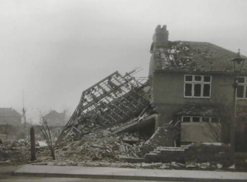
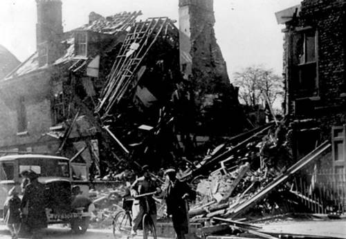
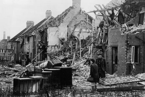
The devastation in Queen Anne's Road (at the top and the bottom of the street).
(Pictures reproduced courtesy of The Press, York......www.thepress.co.uk)
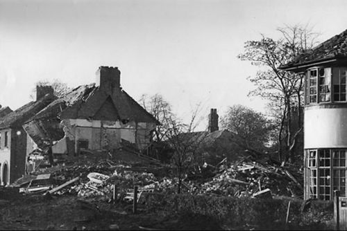
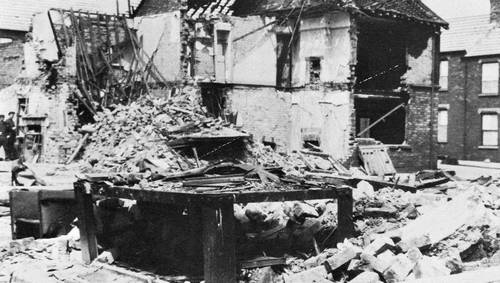
Another image from the Bootham area.
(Picture reproduced courtesy of The Press, York......www.thepress.co.uk)
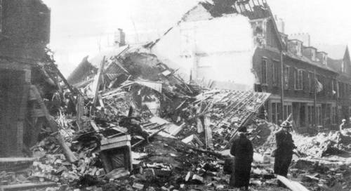
Those close to the railway targets and the main lines suffered badly.......especially Chatsworth Terrace and Amberley Street.
Three residents of 57 Chatsworth Terrace owe their lives to the Morrison Shelter's sturdy construction.
(Picture reproduced courtesy of The Press, York......www.thepress.co.uk)
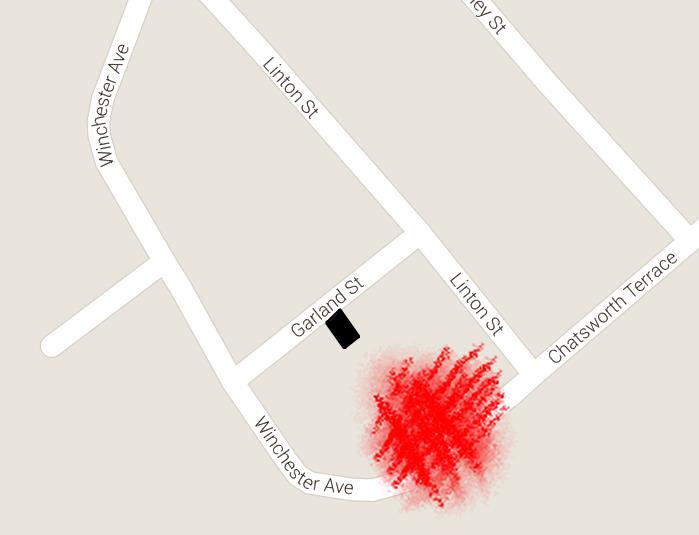
In a nearby home, the occupants survived by hiding in a stronger part of their house. The rear of 11 Garland Street (which backs onto Chatsworth Terrace) was destroyed by the Chatsworth Terrace bomb but Mrs Byworth and her two daughters, hiding under the stairs, were unhurt
In this area, the school on Poppleton Road received a direct hit and 12 out of the 21 classrooms and the central halls were destroyed.
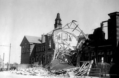
No lessons tomorrow at Poppleton Road Primary School.
(Picture reproduced courtesy of The Press, York......www.thepress.co.uk)
The Manor Higher Grade, Shipton Street, St Barnabas, Queen Anne Secondary and Nunthorpe Secondary schools and the School of Art were all damaged to varying degrees.
Lavender Grove was another street close to the railway lines heading north out of York.
(Picture reproduced courtesy of The Press, York......www.thepress.co.uk)
Being in close proximity to the railway station proved to be dangerous that night. Bombs that fell wide of the target hit the Bar Convent and the Nunthorpe Road area.
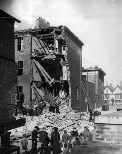
The Bar Convent's East Wing on Nunnery Lane.........five nuns died here
(Picture reproduced courtesy of The Press, York......www.thepress.co.uk)
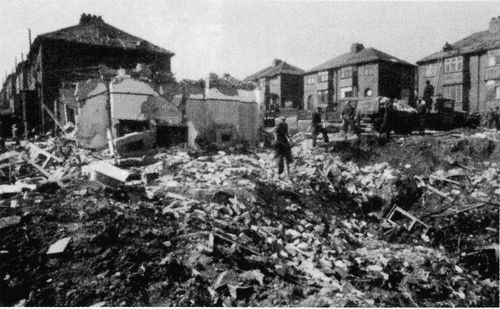
The remains of 19 & 21 Nunthorpe Grove after the air raid.
Five people died in Nunthorpe Road and Upper Price Street.......some 500m distant from Nunthorpe Grove.
(Picture reproduced courtesy of The Press, York......www.thepress.co.uk)
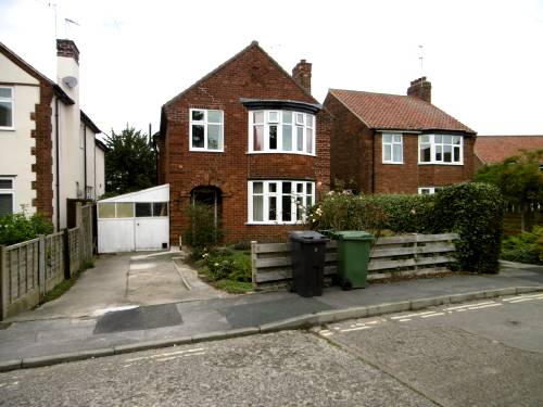
This house (No:7 Petersway) was badly damaged when several small bombs landed nearby.
During the war there was an Anderson shelter just in front of the doors of the white "lean to".
The shelter was never used as there was no drain and it was frequently flooded. On the ground floor, in the front room with the bay windows, there was a Morrison shelter.
Tony Tindall (aged 10) lived here and he recounts the events of that night.
"On the night of the raid of April 29, 1942 my mother roused us from our beds upstairs (we had not used the Morrison shelter that night) as the explosions began. My twin sister and I and my mother took refuge in a cupboard under the stairs. Our lodger, Private Edgar Tomlinson of the Royal Army Pay Corps (stationed in part of the Rowntrees factory), sat in the hallway half-dressed but wearing his tin hat. My father was working in Canterbury, Kent, at this time. The house was not struck directly by any bomb though several small explosions occurred close by. I don’t remember how long the raid lasted but I do remember that at dawn after the bombers had disappeared we walked to the end of Petersway to inspect the source of the smoke from several fires, the largest of which was consuming one of the boarding houses of St.Peters School. There were no fires in Petersway, but our house sustained a large crack in the gable end facing the street and other damage which reached almost to ground level"
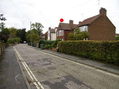
Petersway today (2015) with No:7 marked. The fires from St Peters School would have been seen off the photograph to the LHS.
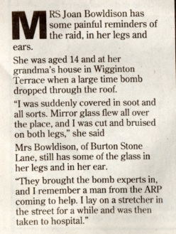
Significant damage could also be caused by bombs which didn't explode. The following picture shows the house and shop on the corner of Wigginton Terrace and Rose Street. After much discussion, it was decided that the damage was done by a 500kg bomb which failed to explode and was subsequently made safe by the Bomb Disposal Squad.
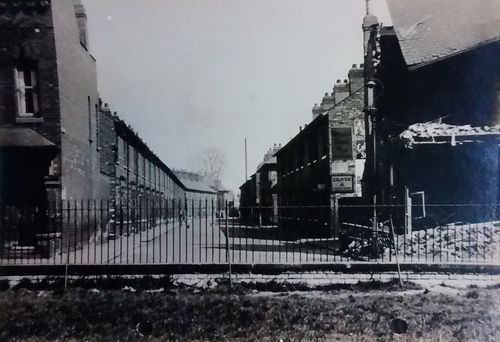
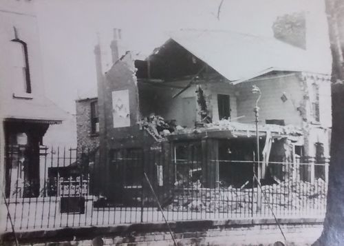
Two views of the damage caused by a 500kb bomb which failed to explode.
Images copyright of the National Archives.
This article from a 1999 Evening Press Supplement adds a more personal view of the incident.
Note that Mrs Bowldison should be Mrs Boldison (information from Don Boldison).
Click the link for a "Then and Now" comparison of this location. The Author would like to thank Darren Lovatt, Allotments Officer, York City Council for (twice) facilitating access to the allotments that now occupy the standpoint of the photographs.
There were 67 serious incidents and 58 major fires.
Almost 400 individual fires were logged.
109 people (householders, civil defence and military) were killed (see Casualty Summary).
Over 200 were injured to varying degrees and, of the 27,000 houses in the city, 579 were rendered uninhabitable. A further 2,500 were damaged to some extent.